


 Vero installs high-tech, hyperlocal weather station
STORY BY JON PINE (Week of April 30, 2026)
Heading out for a day at the beach but want to make sure it’s not raining there? Had to evacuate during a hurricane and want to see what the storm is doing back in Vero? Want to see the sunrise over the ocean, even though you slept late?
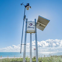
It’s now possible to do all that from the comfort of your home – or anywhere there’s internet access for your smart phone or other device – thanks to a new high-tech hyperlocal weather station installed this month by the City of Vero Beach at the northeast corner of Humiston Park.
The station tracks air temperature, wind speed and direction, rainfall, barometric pressure, heat index, water level in the ocean, and will even tell you where and when the nearest lightning strikes have occurred, providing data in real time, refreshing every 0.8 seconds.
A high-definition video camera with a 120-degree, wide-angle view provides current and historical still images of the beach that you can download, along with streaming time-lapse images and weather data. If you create a free account and log in, you can call up live streaming video. The information is hosted by Weatherstem, a national network of weather stations intended to enhance public safety.
The city chose the site in part because Humiston is a popular, well-used beach, but also because Humiston Park has a stormwater pump station that drains runoff from Ocean Drive during heavy rains, according to Public Works Director Matthew Mitts. “Having accurate, recorded rainfall data at this location will help us monitor the performance of the pump station and inform any potential stormwater improvements we might need to make,” Mitts said.
Savannah Stephens, the city’s GIS (geographic information system) manager in the public works department, worked for nearly three years to secure a grant from the Florida Department of Emergency Management to pay for the $25,000 weather station. FDEM funds about 40 weather stations per year. The grant also covers three years of maintenance at $2,500 per year. The city is responsible for paying the yearly maintenance fee for the remaining seven years on the contract, Stephens said.
The weather station is built to withstand wind gusts of up to 185 miles per hour, which should allow it to survive – and record – the most powerful storms. A Category 5 hurricane is defined by winds of 157 mph and higher, according to the National Oceanic and Atmospheric Administration
Registered users can download the Weatherstem app to set up custom alerts or notifications for severe weather, lightning, or daily weather forecasts. The alerts can be sent by text to a smart phone, by email, or to a social media account, and users can incorporate the data into their own weather maps or applications, Stephens said.
There are more than 400 Weatherstem stations throughout Florida. FDEM has funded about 150 of them and collects data for the state. Most of them can be accessed by adding them city-by-city in the Weatherstem app.
“Humiston was our priority location because of the lift station there,” Stephens said. “When we learned it could be accessed by the public, too, we considered it a win-win for everyone. We’ll see how well it works and how helpful this is for us. And then we can possibly apply again for grants for more weather stations.”
The weather station came online April 3 and is available 24/7 at indianriver.weatherstem.com/fswnverobeach.
Indian River County has weather stations on the Merrill Barber Bridge and at the Indian River Fire Station 5, which is located at 6580 Old Dixie Highway in Winter Beach, and Sebastian Inlet District recently upgraded its weather station with new cameras that provide big, bright, clear streaming images of activity at the north jetty, the mouth of the inlet, the beach and the bridge that spans the inlet. Those images and real time weather information can be seen at sebastianinletcam.com/